
 Explained Map, History, Time Zones, and Key Facts")
What Is North Dakota? A Quick Overview
North Dakota is a state in the Upper Midwest region of the United States, bordered by Canada to the north, Minnesota to the east, South Dakota to the south, and Montana to the west. Known for its vast prairies, dramatic Badlands, and continental climate, North Dakota is one of the least densely populated states in the country — yet it plays an outsized role in American agriculture and energy production.
If you’re searching for “Severna Dakota” (the Macedonian or Bulgarian translation of “North Dakota”), you’ve landed in the right place. This guide covers everything commonly searched about the state: where it is located on the map, its history, its capital and largest city, and — importantly — what time zone it falls under, since North Dakota is one of the few U.S. states split between two time zones.
Where Is North Dakota Located? (Map Overview)
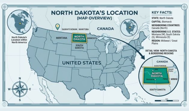
North Dakota sits in the north-central United States, occupying a roughly rectangular shape along the Canadian border. Its geographic coordinates place it between approximately 45.9° and 49.0° north latitude, and the state covers about 70,700 square miles, making it the 19th-largest state by area.
A few geographic landmarks make North Dakota distinct on any map:
- The geographic center of North America is marked in the small town of Rugby, North Dakota — a fact that surprises many people who assume the continent’s center would fall somewhere closer to the U.S.–Canada border’s midpoint or further south.
- The Missouri River runs through the state, passing directly through Bismarck, the capital city, and feeding into Lake Sakakawea, one of the largest man-made reservoirs in the country.
- The Red River of the North forms much of the state’s eastern border with Minnesota and flows northward into Canada — an unusual direction for a major North American river.
- The Badlands, located in the western part of the state, are a rugged landscape of canyons, buttes, and eroded rock formations that look strikingly different from the flat farmland found in the east.
For anyone wanting an interactive view, the U.S. Geological Survey maintains detailed topographic and reference maps of North Dakota’s terrain, county boundaries, and major waterways that go well beyond what a standard road map shows.
North Dakota’s Capital and Largest City
This is one of the most commonly confused facts about the state, so it’s worth being precise:
- Capital city: Bismarck. Located on the Missouri River in south-central North Dakota, Bismarck became the territorial capital in 1883 and retained that status when North Dakota achieved statehood. The city is named after German Chancellor Otto von Bismarck, a choice made in the 1870s to attract German immigration and investment to the Dakota Territory.
- Largest city: Fargo. Located in the eastern part of the state along the Red River, Fargo is the state’s economic and population center, home to over 120,000 residents and anchoring a metropolitan area that extends into neighboring Minnesota. Fargo is also home to North Dakota State University, one of the state’s major research institutions.
So while Bismarck holds the political seat of government, Fargo is the commercial hub — a distinction similar to how Albany is New York’s capital while New York City is its largest city.
North Dakota Time Zone: A State Split in Two
Few states are divided between two time zones, and North Dakota is one of them — a detail that frequently confuses travelers and remote workers scheduling calls with people in the state.
- Eastern and central North Dakota (including Bismarck and Fargo) follow Central Time (CT), which is UTC−6 during standard time and UTC−5 during daylight saving time.
- The far western counties (including areas near Williston and parts of the Badlands) follow Mountain Time (MT), which is UTC−7 during standard time and UTC−6 during daylight saving time.
The dividing line roughly follows county boundaries in the western third of the state, including McKenzie County, which itself straddles both zones. Like the rest of the United States, North Dakota observes daylight saving time, shifting clocks forward in March and back in November. If you need to confirm the exact current time for a meeting or call, the U.S. government’s official time reference at time.gov provides synchronized time data across all U.S. time zones, including both zones used in North Dakota.
A Brief History of North Dakota
Early Indigenous History
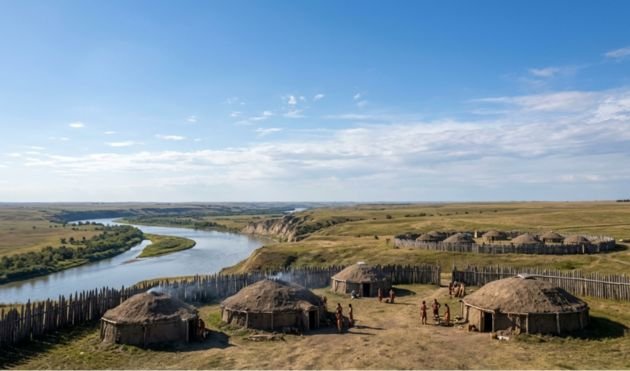
Long before European settlement, the region now known as North Dakota was home to several Native American nations, including the Mandan, Hidatsa, and Arikara peoples, who established permanent earth-lodge villages along the Missouri River and developed extensive trade networks across the Great Plains. The Dakota and Lakota (Sioux) peoples also inhabited and moved through the region, particularly in the eastern and southern areas.
These communities had thriving agricultural and trading economies centuries before contact with European explorers — a history that the State Historical Society of North Dakota documents extensively through preserved village sites, artifacts, and oral histories.
Exploration and the Lewis and Clark Expedition
The Lewis and Clark Expedition passed through present-day North Dakota in 1804–1805, spending the winter near the Mandan and Hidatsa villages close to today’s Washburn, North Dakota. It was here that the expedition met Sakakawea (commonly spelled Sacagawea), who joined the journey as an interpreter and guide. This period remains one of the most documented chapters in the state’s early written history, and several historic sites along the Missouri River preserve this legacy today.
Territorial Period and Statehood
The Dakota Territory was organized in 1861, encompassing what would become both North and South Dakota. As settlement increased — driven by railroad expansion and the Homestead Act, which offered land to settlers willing to farm it — pressure grew to split the territory into two states.
On November 2, 1889, North Dakota and South Dakota were both admitted to the Union as the 39th and 40th states. (The order between the two has long been a point of local trivia, since President Benjamin Harrison reportedly had the documents shuffled before signing so no one would know which state was technically admitted first.)
20th Century Growth: Agriculture and Energy
Throughout the 20th century, North Dakota’s economy was built primarily on wheat farming, which remains a defining feature of the state’s identity and economy today. The state consistently ranks among the top producers of wheat, barley, sunflowers, and canola in the United States, according to data published by the U.S. Department of Agriculture.
In the early 21st century, the discovery and development of the Bakken Formation — a massive oil and natural gas deposit in the western part of the state — triggered one of the fastest economic booms in recent U.S. history. Towns like Williston saw population growth rates that outpaced almost anywhere else in the country during the 2010s, fundamentally reshaping the demographics and infrastructure of western North Dakota.
North Dakota Today: Population, Economy, and Identity
North Dakota’s population has historically hovered around 750,000–800,000 people, making it one of the least populous U.S. states — yet its land area means it has one of the lowest population densities, with vast stretches of open prairie between towns.
The state’s economy today rests on three main pillars:
- Agriculture — North Dakota remains a national leader in wheat, soybean, and sunflower production, with farming culture deeply embedded in the state’s identity.
- Energy — Oil extraction from the Bakken Formation continues to be a major economic driver, particularly in McKenzie, Williams, and Mountrail counties.
- Education and healthcare — Institutions like North Dakota State University in Fargo and the University of North Dakota in Grand Forks anchor significant employment and research activity, particularly in aerospace, unmanned aircraft systems, and agricultural science.
Things North Dakota Is Known For
If you’re researching the state for travel, relocation, or general knowledge, here are the landmarks and cultural touchpoints that consistently come up:
Theodore Roosevelt National Park. Located in the western Badlands, this park preserves the rugged landscape where a young Theodore Roosevelt ranched in the 1880s — an experience that shaped his later conservation policies as U.S. President. The National Park Service maintains detailed visitor information, trail maps, and historical context for the park’s North and South Units.
The International Peace Garden. Straddling the U.S.–Canada border in north-central North Dakota, this garden was established in 1932 as a symbol of friendship between the two countries and remains a popular destination for visitors from both sides of the border.
Norsk Høstfest. Held annually in Minot, this festival celebrates the strong Scandinavian heritage that shaped much of North Dakota’s settlement, particularly Norwegian, Swedish, and Icelandic immigration in the late 19th century.
The Geographic Center of North America. As mentioned earlier, this marker in Rugby is a small but frequently visited landmark, often included on road-trip itineraries for travelers crossing the northern Plains.
Severna Dakota vs. North Dakota: Clearing Up the Terminology
For readers who arrived here searching in Macedonian, Bulgarian, or another Slavic language, “Severna Dakota” is simply the direct translation of “North Dakota” — “severna” meaning “northern.” There is no separate place, region, or entity called “Severna Dakota” distinct from the U.S. state of North Dakota; it’s purely a linguistic translation that appears in encyclopedic entries, including the Macedonian and Bulgarian-language versions of Wikipedia, which mirror the English Wikipedia’s structure for U.S. state articles — covering geography, history, demographics, and government in the same format.
Quick Reference: North Dakota at a Glance
- Capital: Bismarck
- Largest city: Fargo
- Statehood: November 2, 1889 (39th state)
- Time zones: Central Time (most of the state) and Mountain Time (far west)
- Bordering Canadian provinces: Manitoba and Saskatchewan
- Major rivers: Missouri River, Red River of the North
- Notable park: Theodore Roosevelt National Park
- Key industries: Agriculture (wheat, soybeans, sunflowers) and energy (Bakken oil formation)
Frequently Asked Questions
What is the capital of North Dakota?
Bismarck is the capital of North Dakota, located along the Missouri River in the south-central part of the state.
What is the largest city in North Dakota?
Fargo is North Dakota’s largest city, located in the eastern part of the state near the Minnesota border.
What time zone is North Dakota in?
Most of North Dakota, including Bismarck and Fargo, follows Central Time. The far western counties near the Montana border follow Mountain Time, making North Dakota one of the few U.S. states split across two time zones.
When did North Dakota become a state?
North Dakota became the 39th U.S. state on November 2, 1889, admitted to the Union on the same day as South Dakota.
Is “Severna Dakota” a different place from North Dakota?
No. “Severna Dakota” is simply the Macedonian and Bulgarian translation of “North Dakota” and refers to the same U.S. state.
Final Thoughts
Whether you’re researching North Dakota for travel planning, academic purposes, or simply curiosity sparked by an encyclopedia entry, the state’s identity rests on a handful of consistent themes: its split time zones, its dual identity as both an agricultural heartland and an energy powerhouse, its rich Indigenous and pioneer history, and landmarks like Theodore Roosevelt National Park that draw visitors from across the country. Understanding these core facts gives you a solid foundation for any deeper research into the state’s geography, history, or current affairs.